Recent searches
Search options

Administered by:

#geopandas


Something going on with #geopandas on #Windows today that broke @movingpandas unit tests? https://github.com/movingpandas/movingpandas/actions/runs/14266650165/job/39992053542


Thank you to #Kone & Mai and Tor Nessling Foundations for supporting this work. A quantitative work like this would not be possible without a robust suite of FOSS tools. My thanks to the maintainers of #QGIS, #pandas, #geopandas, #duckdb, #dask, #statsmodels, #jupyter and many more!

Seeking recommendations for a #WebMapping tutorial / course?
Slightly at sea on where to start.
- My current JS skill level is _extreme novice_.
- I don't have access to ArcGIS.
- Comfortable with #QGIS [*] and the #python #geospatial ecosystem (#geopandas #xarray #rasterio and plotting with #matplotlib)
Suggestions welcome. TIA. 
* I have looked at the qgis2web plugin, but having some issues associated with my aged laptop (2012 mbp running Ubuntu) and a 'Wayland session'.

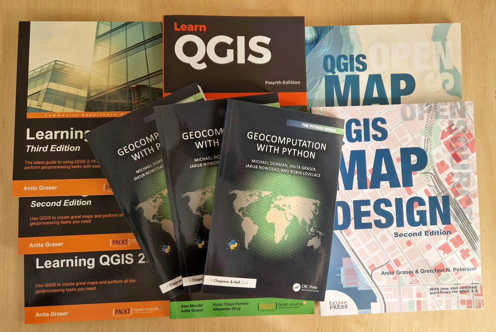
 Geocomputation with Python copies have arrived
Somehow, things feel much more real if you can touch them.
Fun fact: the cover was designed in #QGIS. Speaking of going full circle ...

 Qiita - 人気の記事
 Uberの作った「H3インデックス」とGeoPandasを利用してOverture Mapsの可視化と地理空間解析してみる!
https://qiita.com/nokonoko_1203/items/ce8937489121b69710e5?utm_campaign=popular_items&utm_medium=feed&utm_source=popular_items

The development was supported by NumFOCUS (small development grant for the #GeoPandas project). A lot of the credit goes to @jorisvandenbossche and @paleolimbot (through S2Geography). Also many thanks to the new contributors!
https://github.com/benbovy/spherely
Joris is going to give a talk about it next week at the GeoPython conference in Basel. If you go there, don’t miss it!

Une carte complètement inutile, donc indispensable. À quelle latitude le Soleil survole-t-il le plus de terres émergées ?
#Python #Geopandas
#maps #TeamCarto
. Dans la zone intertropicale, des lignes horizontales barrent les continents ; leur couleur va de l'orange clair au rouge. À gauche, dans le Pacifique, un histogramme à barres horizontales avec les mêmes lignes colorées. En légende en bas : maximum 36.7% de terres émergées, latitude 22.97° 10 juin et 4 juillet.")


@christyheaton kicks us off at #pycascades2025 by talking about how to make hiking maps with #pyscript, #geopandas, and #streamlit 


#pycascades #python


#dataviz #python #geopandas #matplotlib #affinity


Number of scholastic buildings per administrative area in Ravenna, 2022
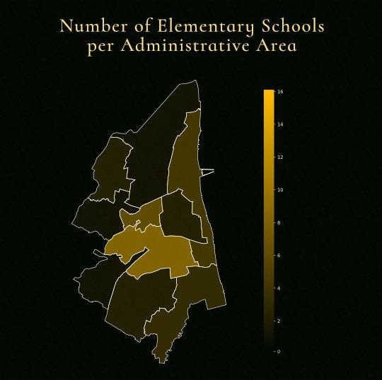
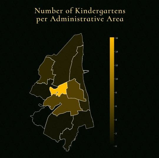
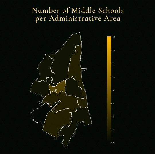
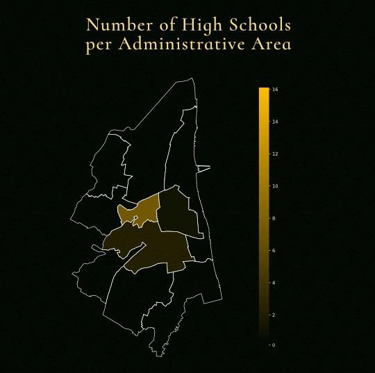
School coverage across the Ravenna province by grade, an analysis to measure how many children live within a 15-minute walking distance of a school.
This post only displays the areas covered by schools due to privacy and safety considerations (GDPR).


This post only displays the areas covered by schools due to privacy and safety considerations in compliance with GDPR regulations.
#dataviz #python #geopandas #matplotlib #qol


"R⁵py is a #Python library for rapid realistic routing on multimodal transport networks (walk, bike, public transport, and car). It provides a simple and friendly interface to R⁵, the Rapid Realistic Routing on Real-world and Reimagined networks, a routing engine developed by Conveyal. #r5py is inspired by r5r, a wrapper for R, and it is designed to interact with #GeoPandas #GeoDataFrames."
https://r5py.readthedocs.io/en/stable/index.html
via @waeiski
#GeoParquet in #QGIS – smaller & faster files for the win!
tldr; Tired of working with large CSV files? Give GeoParquet a try!
http://anitagraser.com/2024/11/23/geoparquet-in-qgis-smaller-faster-files-for-the-win/
The #GeoPython2024 recordings just dropped, including this #GeoPandas workshop

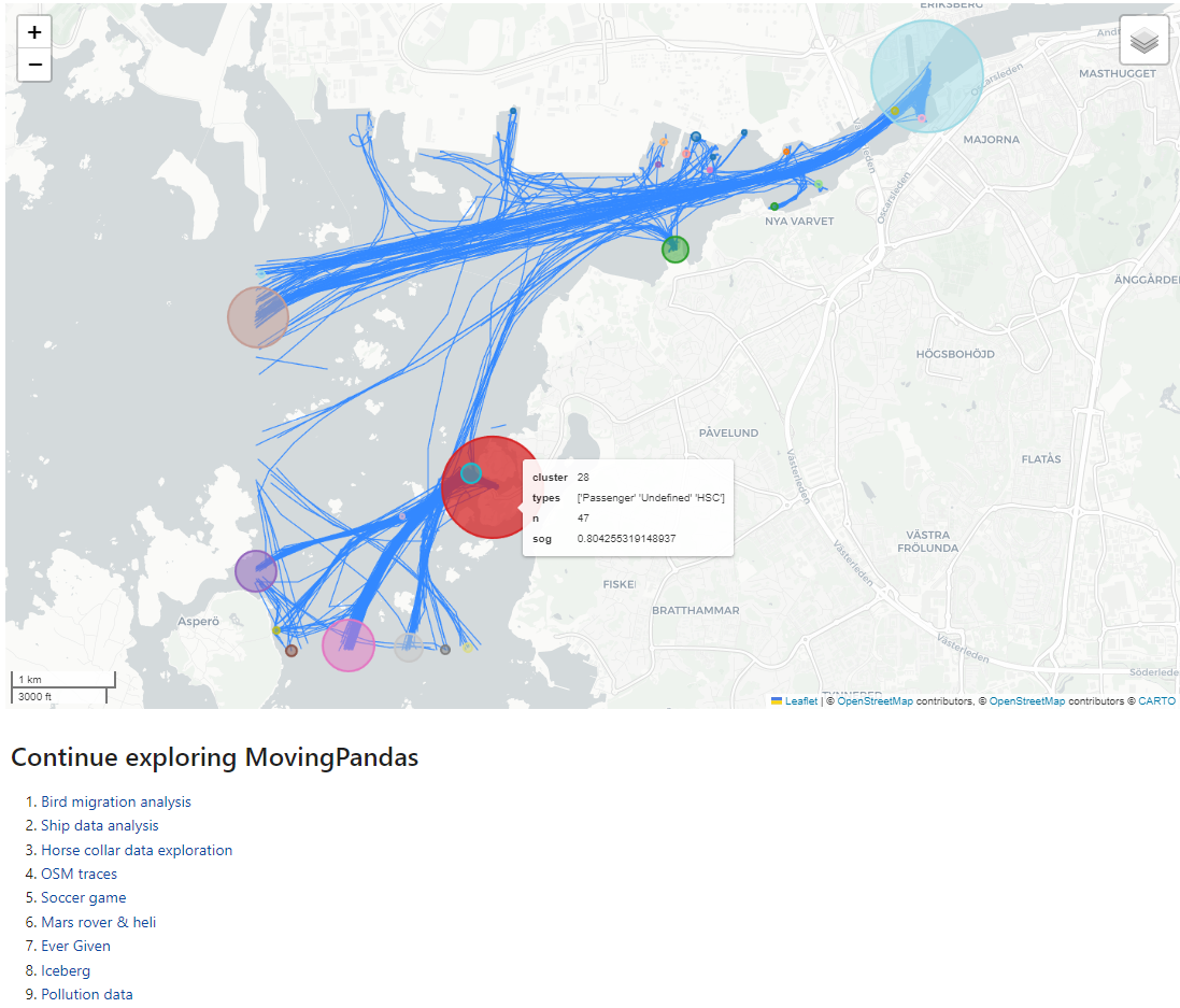
Our tutorials and analysis notebooks now come with plenty of usage examples for the new explore() function which provides #folium powered interactive plots
You probably already know and appreciate it from #GeoPandas and now you can also enjoy it in #MovingPandas